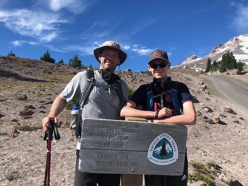
I’m not sure when it was over the last 14 years that I’ve lived in Oregon that I heard about the Timberline Trail that circumnavigates Mt. Hood, but I’m pretty sure that once I heard about it that I knew I had to do it.. but I had to find some folks to do it with me. My oldest turned 15 last December and at a campout over Memorial Day weekend with some friends, he mentioned that he’d be up for it, which immediately started my countdown timer and set plans in motion.
I planned and then hiked a couple of trails (7 miles for Lolo Pass to Bald Mountain and back, 10 miles on the Twin Lakes loop, and 15 miles for Horseshoe Ridge / Cast Lake) which doubled as Boy Scout Hiking Merit Badge activities for my son, and then pored over a bunch of blog posts (1, 2, 3) that described where to camp, how long to hike, what to watch out for, and what the experience was like. I put together a plan, which changed slightly as I read about campsites, and eventually ended up with this:
- Friday (afternoon / evening): Timberline Lodge to Paradise Park (~5 miles)
- Saturday: Paradise Park to Cairn Basin (~16 miles)
- Sunday: Cairn Basin to Tilly Jane Campground (~9 miles)
- Monday: Tilly Jane Campground to Timberline Lodge (~14 miles)
which enabled us to minimize vacation days and get the trail done with a couple of 15 year old boys who are go-getters but might not have bitten off on 3 consecutive 15 mile+ days on the trail.
Day 1: The weather this past weekend worked out well.. except for Friday night which was cloudy and rainy and led to epic views of Mt. Hood on the trail like this:
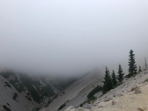
We started out around 3pm on Friday afternoon from Timberline Lodge and hiked the approximately 5.5 miles with 1200 feet of elevation gain to Paradise Park in a little less than 3 hours… which was important because at about 2.5 hours it started to drizzle and rain. We found an cozy campsite that was slightly west of the main trail (Paradise Park is a popular / easy hike and there were at least 4 other obvious campsites already in use) and settled in for the night after dinner. It rained (not drizzled) until maybe 1am but the clouds cleared and the sun came out the next morning for an Day 2 that started with gorgeous views:
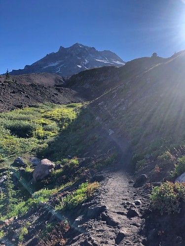
Day 2: We got up early, had coffee, packed up, and started the longest day of the trip, which ended up being more than 16 miles and 3k feet of elevation gain, with a backpack, at least according to my Suunto GPS watch. This was definitely the longest and hardest day on the trail. We stood on the top of beautiful ridges,

saw a bunch of campsites (for the next trip), and took selfies at Ramona Falls

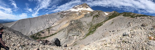
before starting the long climb to Bald Mountain, McNeil Point, and eventually Cairn Basin. Water was scarce between Bald Mountain and McNeil Point and the 16 miles we did that day was draining… but refilling our water and getting snacks onboard late in the afternoon energized everyone and we eventually made it to Cairn Basin, with views like this:

Tons of campsites at Cairn Basin, relatively few hikers there, but lots of mosquitoes. Don’t forget your bug spray.
Day 3: a purposefully easy hike from Cairn Basin to Tilly Jane Campground, where our significant others were planning to meet us for a car camping extravaganza (steaks! potatoes! greens!) and to enable us to offload the big packs so that we could go light on Day 4. We passed a bunch of gorgeous campsites and larger campgrounds like Elk Cove, skipped over an amazing number of big and small rivers and creeks, and eventually arrived at Tilly Jane Campground literally within seconds of our SO’s arriving in a car. Oh wait, I skipped over the hardest part. At about mile 7 of the trek, we got a glimpse of Cloud Cap Inn and we all got that “we’re so close!” feeling… and then you hit the new Eliot trail (the old one was unusable after being washed out a couple years ago), where you lose 600 feet over a bunch of switchbacks, have to cross the Eliot Branch (I took a swim by accident, there is a big log to cross over but we didn’t see it), and then climb back up 600 of vertical wall, all in about 1 mile.
Day 4: pack up multiple tents, had an satisfying breakfast (sausage, egg, and cheese muffins), and hit the trail with a bang. 1k feet of elevation gain right off the bat to get back to Timberline trail from Tilly Jane in a moonscape:

A couple miles later we came around a bend and were all very impressed with Gnarl Ridge and Lamberson Spur:
which I’ve never been up close and personal with, and are breathtaking. After 14 miles, almost 4k feet of vertical gain, and more than 7 hours on the trail, we finally made it back to Timberline Lodge:
Things I’ll remember / change:
- Green Trails Maps are super informative (the horizontal mileage and elevation grid for the trail is a nice addition), compact, and waterproof (mine took a swim), buy one for your next trip.
- My son and I both sported Altra Trail Running shoes and Altra gaiters… and had no blisters, no foot pain, and never had to take our shoes off to shake out debris. Highly recommended in lieu of heavy hiking boots.
- Instead of buying backpacking food containers, I did a couple of DIY backpacking meals from Andrew Skurka, namely the Rice & Beans (on Saturday night), and the Quickstart Cereal (2 separate mornings), both of which entered the clean plate… err bag club.
- I bought a Jetboil FluxRing Cooking Pot before the trip, hoping to be able to use it to cook the rice and beans… and literally the first time I used it, I burned a hole in the bottom plastic cover because I forgot to remove it. Looking at the reviews on the replacement part, it looks like I’m not the first… and won’t be the last to make the same mistake. Hopefully there’s a product designer somewhere at JetBoil who’s thinking about UI hints that could be added that would dramatically reduce the # of people who burn holes in the protective cover.
- Having hiking sticks / poles to get across creeks was money.
- I used pine needles / grass to clean my pot (tip from REI) after making the rice / beans, which worked well.
- If you forget that your JetBoil lighter doesn’t work, make sure to bring matches or a friend who brings matches.
- Brought way too much food, need to dial the quantities back next time to save weight.
- Clockwise around the mountain seemed like the way to go… maybe it was just that we were all exhausted by the 4th day, but the trail through White River / Mt. Hood Meadows seemed boring / desolate compared to the other start through Paradise Park.
- The night before and the day of the trip was a little nerve wracking… I knew I could do it but I think my mind also knew that it would be hard. My son had a sunburn on his shoulders and pushed (not too hard) to back out at the last minute… but the last day and the day after were very satisfying. I’ve bookmarked a number of quotes (1, 2, 3, 4, 5) that talk about the act of pushing yourself into uncomfortable places being a source of growth and joy… or as Eric Larsen wrote in a blog post awhile back: “… One of my favorite authors, Sigurd Olsen, used the term ‘Lighting Out’ to describe the physical act of leaving the comfort and convenience of modern civilization and heading out into the wilderness. For some, purposefully putting yourself in uncomfortable situations seems ridiculous at best.”… and I really felt that after the trip. I slept horribly the last night, the last 5 miles was draining, and everything ached the day after… but unplugging and being with people and in nature, was something I desperately needed. Lighting out. Love that.
I’ll definitely do it again someday… maybe in 5 years when the next one turns 15.